August 2, 2026 12:30 p.m. | Effective Immediately
Hagen Fire Evacuation Levels Reduced
Joint release from the Umatilla County Sheriff’s Office, Umatilla County Emergency Management, Union County Sheriff’s Office, Union County Emergency Management, and the Confederated Tribes of the Umatilla Indian Reservation (CTUIR)
The Joint Emergency Operations Center remains actively engaged with Northwest Incident Management Team 7 on the Hagen Fire. Following a review of current fire conditions, some evacuation zones are being reduced (zones listed below).
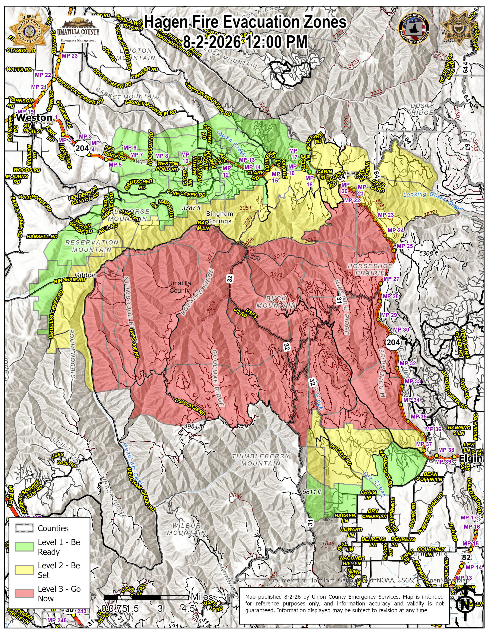
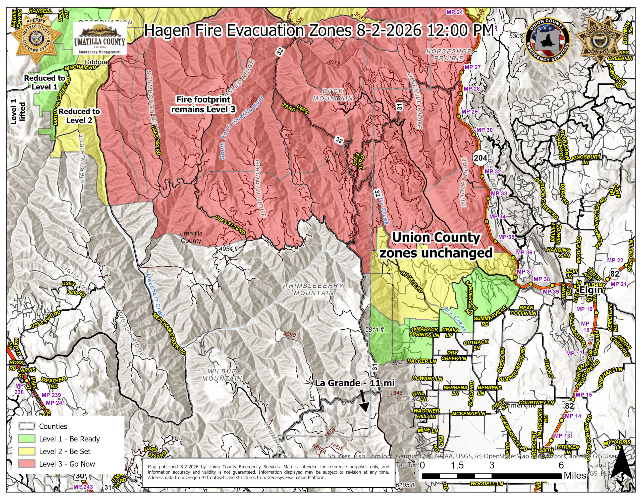
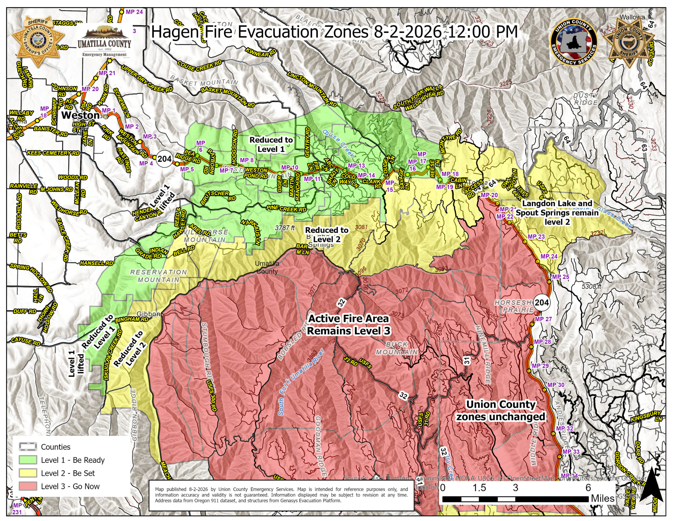
Previous evacuation levels issued in the area east of Meacham Creek have dropped down one level (see map).
Previous evacuation levels issued in areas west of McEntyre Road, south along NF 3719 Road and north of the North Fork of the Umatilla River have also dropped down one level (see map).
Residents in the area should check the current maps prior to returning to ensure they are informed regarding the current evacuation levels in their area.
Residents returning to reduced evacuation areas should also use caution and watch for firefighters, heavy equipment, smoke, debris, weakened trees, and ongoing suppression work. Those who do not live in the affected area are asked to stay out so crews and local landowners can work safely and without interference.
A reduction in evacuation level does not automatically reopen closed roads, trails, campgrounds, or restricted areas. Continue following all posted closures.
The following Zones have been reduced in Umatilla County. All other evacuation zones remain unchanged.
Reduced from Level 3 to
LEVEL 2 (BE SET)
- UMC-123-E
- UMC-1406007-B
- UMC-1406020
- UMC-1406056
- UMC-149-B
- UMC-149-C
- UMC-153
- UMC-215-A
- UMC-215-D
- UMC-215-E
- UMC-243
Reduced from Level 2 to
LEVEL 1 (BE READY)
- UMC-075B
- UMC-75C
- UMC-117-H
- UMC-117-I
- UMC-119-B
- UMC-121-A
- UMC-121-B
- UMC-123-B
- UMC-123-C
- UMC-149-D
- UMC-151-D
- UMC-151-F
- UMC-151-G
- UMC-151-H
- UMC-155-A
- UMC-155-B
- UMC-157
- UMC-215-C
- UMC-215-F
Evacuation Notices Removed
(Returned to Normal Status)
- UMC-147-B
- UMC-151I
- UMC-213-D
- UMC-213-E
The western containment line at Rattlesnake Ridge and the northern line near Bingham Road held through yesterday’s wind event. Multiple spot fires occurred east of Forest Service Road 31, and crews worked through the night to contain those spots and strengthen the road as a containment line.
Although the fire is holding along portions of the north and west sides, it continues to progress southeast and due east along the North Fork of the Umatilla River. Firefighters, equipment operators, aviation resources when conditions allow, incident personnel, supporting fire agencies, and local landowners remain actively engaged.
These evacuation reductions reflect improved conditions in the affected areas. The Joint Emergency Operations Center will continue taking a careful and measured approach to public safety while also returning residents to their homes as soon as conditions make that appropriate and feasible.
The Joint Emergency Operations Center appreciates the patience and cooperation of affected communities throughout this incident. If you see a firefighter or equipment operator working in the area, please take a moment to thank them. Many have worked long hours under difficult and changing conditions to protect residents, property, and our communities.
Official Information
Current Evacuation Map:
https://protect.genasys.com/en?lat=45.6881&lng=-118.4046&z=10.7
RAPTOR Incident Map:
https://arcg.is/0SjKLG1
Umatilla County Emergency Advisories:
https://www.co.umatilla.or.us/departments/sheriffs-office/emergency-management/emergency-advisories
Union County Emergency Services:
https://unioncountyor.gov/emergency-services/es-current-alerts/
Sign Up for Emergency Alerts:
https://oralert.gov/
Overview map of entire incident: