(Umatilla County, Union County, Confederated Tribes of the Umatilla Indian Reservation)
August 31, 2026 at 1:00 p.m.
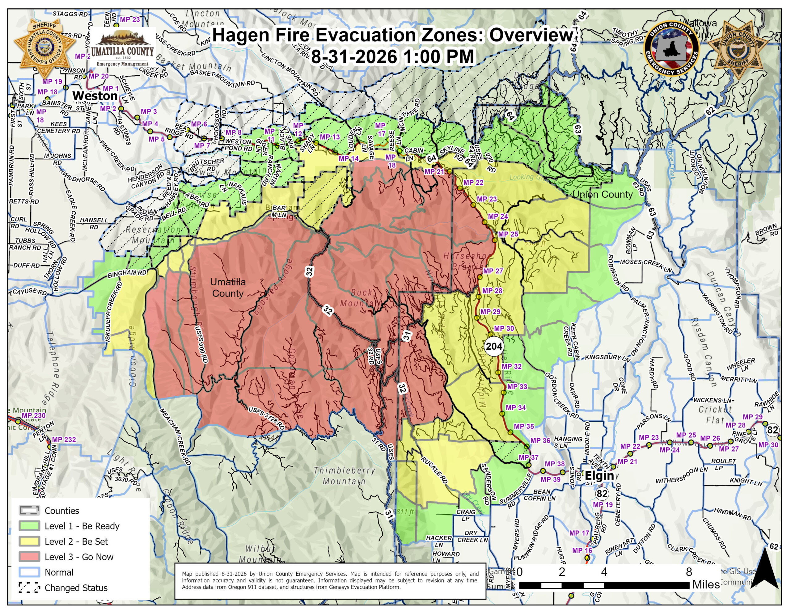
Continued progress on the Hagen Fire is allowing emergency officials to further reduce or lift evacuation levels in portions of Umatilla County, Union County and the Confederated Tribes of the Umatilla Indian Reservation (CTUIR).
Fire activity on the Hagen Fire has continued to moderate. Crews remain actively engaged throughout the fire area, securing and mopping up control lines, addressing remaining areas of heat and continuing protection of structures, private property and critical infrastructure. Firefighters, engines and other apparatus will remain active throughout the affected areas as suppression work continues.
Effective immediately, the following evacuation levels have been REDUCED or LIFTED:
LEVEL 3 (GO NOW) REDUCED TO LEVEL 2 (BE SET)
UMATILLA COUNTY AND CTUIR
Evacuation Zones:
UMC-157-B
UMC-243
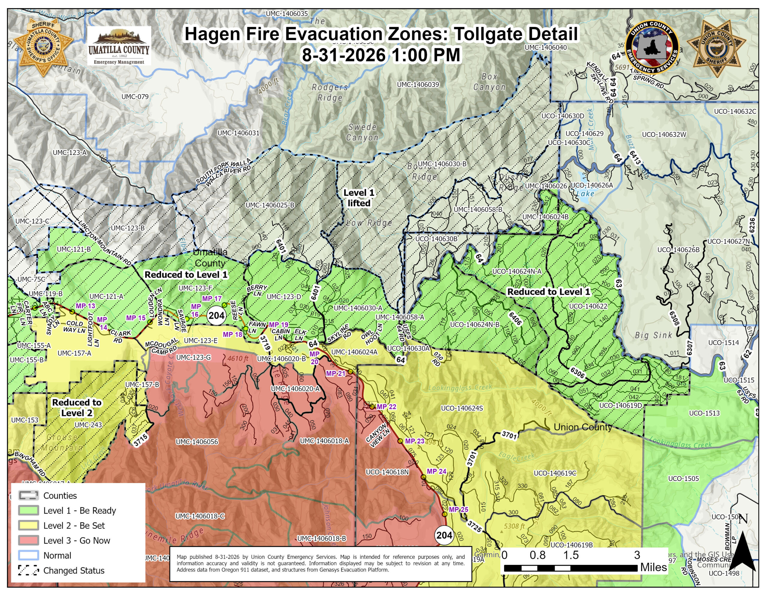
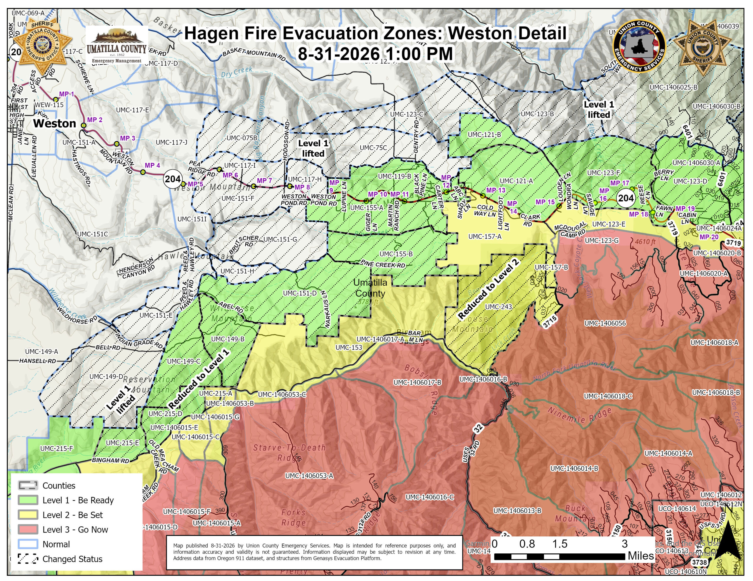
Includes: Areas south of Highway 204 in the Horse Mountain and Lick Creek area, extending generally south and west from the Cold Springs/McDougal Camp Road area toward USFS Road 3715.
LEVEL 2 (BE SET) REDUCED TO LEVEL 1 (BE READY)
UMATILLA COUNTY AND CTUIR
Evacuation Zones:
UMC-119-B
UMC-121-A
UMC-121-B
UMC-123-D
UMC-123-F
UMC-1406024B
UMC-1406030-A
UMC-1406058-A
UMC-149-B
UMC-149-C
UMC-151-D
UMC-155-A
UMC-155-B
UMC-215-D
UMC-215-E
Includes: Areas east and southeast of Weston and north of Bingham Road, including portions of Abel Road, Pine Creek Road and the Weston Mountain area. Also included are areas along and north of Highway 204 through the Lincton Mountain, Cold Springs and Tollgate areas, extending east toward USFS Road 64 and the Umatilla/Union County line near Jubilee Lake.
UNION COUNTY
Evacuation Zones:
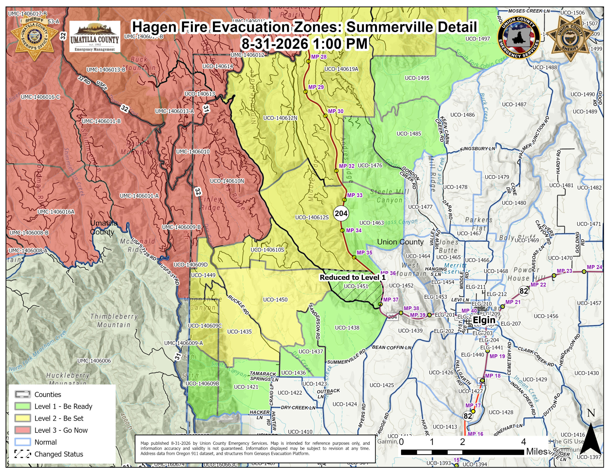
UCO-1451
UCO-140619D
UCO-140622
UCO-140624N-A
UCO-140624N-B
The area southeast of the USFS 64 Road and southwest of the USFS 63 Road extending south to the USFS6400-030 road and Lookingglass Creek below the confluence with Swamp Creek. Also the area of south of the USFS boundary that is east of Phillips Creek Road and west of Hwy 204.
LEVEL 1 (BE READY) LIFTED / EVACUATIONS REMOVED
UMATILLA COUNTY AND CTUIR
Evacuation Zones:
UMC-075B
UMC-117-H
UMC-117-I
UMC-123-B
UMC-123-C
UMC-1406025-B
UMC-1406030-B
UMC-1406058-B
UMC-149-D
UMC-151-E
UMC-151-F
UMC-151-G
UMC-151-H
UMC-75C
UMC-1406026
These zones have returned to normal status and are no longer under an evacuation level.
Includes: Areas east and southeast of Weston, including portions of Weston Pond Road, Wildhorse Road, Indian Grade Road and the Highway 204 corridor. Also included are areas north of Highway 204 along Lincton Mountain Road and South Fork Walla Walla River Road extending toward Tollgate, along with National Forest areas north of the Tollgate corridor and the small area near Jubilee Lake.
UNION COUNTY
Evacuation Zone:
UCO-140630B
The area to the northwest of the USFS 64 Road within Union County.
These additional reductions and lifted evacuation levels are an encouraging sign of the continued progress on the Hagen Fire. Firefighters, engines and other fire apparatus will continue working throughout the area as crews strengthen containment features and complete additional suppression and mop-up work.
Residents and travelers should continue to expect fire personnel, engines, heavy equipment and emergency vehicles operating in and around the affected areas. Drivers are asked to slow down, remain alert and give crews and equipment room to work.
All other evacuation areas not listed above remain at their current evacuation level.
- Watch for Fire Crews: Drivers should slow down, remain alert and watch for firefighters, engines, heavy equipment and trucks entering and exiting roadways.
- Respect Closures: All applicable U.S. Forest Service road and area closures remain in effect.
Emergency officials from Umatilla County, Union County, CTUIR and partner agencies continue to coordinate closely with fire managers and evaluate conditions. Additional adjustments to evacuation levels will be made as conditions allow.
Current Evacuation Map – Genasys:
https://protect.genasys.com/en/map/45.677461%2C-118.225679/hazards/d4e53810-46d0-48fb-889b-3e670328dcfb?lat=45.6775&lng=-118.2257&z=10.7
Current Evacuation Map – Raptor:
https://arcg.is/0SjKLG1
Umatilla County Emergency Advisory Information:
https://umatillacounty.net/departments/sheriffs-office/emergency-management/emergency-advisories
Union County Emergency Services:
https://unioncountyor.gov/emergency-services/es-current-alerts/
Sign up for emergency alerts:
www.oralert.gov
Continue to follow official fire updates at Paradise, Hagen and Horse Ridge Fire Information:
https://www.facebook.com/profile.php?id=61592064000400